Waterways management in the east Kimberley rangelands: A perspective from Kachana Station
A.W. StoreyAdjunct Senior Lecturer, School of Animal BiologyThe University of Western Australia
From a southern Australian perspective, the Kimberley Region is promoted as the last frontier - a pristine wilderness. This may be true for some of the more inaccessible parts of the region, but the rangelands, subjected to cattle grazing by the pastoral industry since the late 1800s, are far from pristine, with the combined effects of overgrazing, poor stock management and uncontrolled and too frequent fire taking their toll on the land – and the rivers.
From a waterways perspective, it is generally perceived by the wider community that the rivers of this fragile landscape are characterised by massive wet season floods and high sediment loads, reflecting combined effects of high intensity rainfall and sparse vegetative cover to hold the soil together. However, it is a fallacy to assume that these rangeland catchments always had a high run-off coefficient, that water never remained on the land for long, and that erosion is part and parcel of this landscape. Some of the sources of these problems are clearly evident in the dry season when the rivers have receded to isolated pools. It is not uncommon to see cattle congregating around watercourses and destabilising banks, or see the landscape denuded of vegetation either by overgrazing or fire. These are the pressures that lead to increased run-off and erosion. It is proposed that the waterways of the rangelands were not always like this – and should not be left like this.
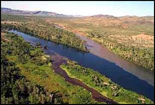
The Water & Rivers Commission (WRC, 1997), when commenting on the state of the rivers in the north of Western Australia, considered that the most serious cause of river degradation in the Kimberley was the removal of the natural riverine and catchment vegetation resulting in increased rates of runoff, leading to soil erosion and sedimentation of the rivers. It was considered that very intensive grazing pressure over wide areas had destroyed the vegetation and exposed the fragile soil structure to the impact of highly intense rainfall (WRC, 1997). This had resulted in widespread sheet and gully erosion across much of the Kimberley, and once started, gully erosion in particular was very difficult to halt. Erosion was then exacerbated by stock trampling around pools and billabongs, where they congregated if left to range (WRC, 1997). Once eroded from the landscape, soil washed into the rivers, making them highly turbid when flowing (Plate 1), and was then deposited along river banks, in pools and across estuaries.
WRC (1997) highlighted siltation of pools as a threat to the ecology of Kimberley rivers. Many of the rivers of the region naturally recede to isolated pools in the dry season, and these pools provide critical refuges for water-dependent fauna (i.e. fish, insects, prawns, freshwater and estuarine crocodiles, tortoise and waterbirds). However, sediment from erosion initially smothers the animals living on the bottom, coats organic deposits and algae upon which the fauna depend as a food source, and then covers and in-fills habitat (i.e. covers woody debris, gravel beds, undercuts, hollows etc). As the silt deepens, the pools become shallower, water temperatures generally increase, as do diurnal changes in oxygen levels, making the pools less suitable for fauna. Eventually, the pools are totally in-filled and no longer provide a refuge in the dry season. If this process occurs along the length of a river, dramatic losses in biodiversity will eventuate.
Increased frequency of fire, particularly late dry season hot fires is having a similar detrimental effect on the Kimberley landscape and its rivers. This was highlighted in the 2001 Kimberley Fire Forum (Kohen, 2003), which concluded that high frequency, uncontrolled, hot burns were devastating native flora. From a waterways perspective, late dry season hot fires remove vegetation, leaving the soils exposed to the forthcoming high intensity wet season rains, the result being rapid run-off and erosion.
Interestingly, the hydrological and morphological problems commonly observed on the Kimberley rangelands are considered unacceptable if they occur in the southwest of the State. If a creek in the south-west is eroding, we look to its catchment for the reasons, and very quickly implement restorative catchment management. The first actions are to re-plant vegetation to reduce run-off, stabilise banks using natural materials (i.e. woody debris, matting, rocks, brushing and revegetation), minimise direct causes of erosion (i.e. exclude stock) and shade the watercourse by replanting riparian zones. Catchment groups and natural resource managers will intercede with ‘soft engineering’ solutions to prevent further degradation. This may be in the form of building rock riffles to prevent gully erosion, or re-introducing large woody debris or rock material to stabilise banks and try to protect ecological assets (i.e. riparian trees, pools and riffles, and the aquatic fauna and flora dependent upon this habitat). If stock are in the creek, they are excluded with fencing and either provided off-river watering points or limited access points. Yet, in the Kimberley, there is broad scale erosion due to loss of vegetation from stock and fire, and the ecological (and economic) resources are washing away – and no action is being taken. Is a new mindset needed, should these issues be managed or is the problem too large?
From a hydrological perspective, the processes by which catchments operate, and rivers function are no different between the southwest of the State and the Kimberley. Once a catchment is denuded of vegetation, there is greater and faster rainfall runoff. Faster flows have greater power, and as a result the creeks and rivers erode, leading to sedimentation of the water course. Removal of vegetation by burning gives a similar response. In addition, in areas with a high evaporation to rainfall ratio, loss of vegetation will cause soil profiles to dry, water tables to drop and creeks to become more seasonal. In the south west of the state these problems are addressed by catchment management, however they are also evident in the Kimberley rangelands, but on the whole they go unheeded.
Kachana Station, nestled in the Durack Ranges, 30 mins flying time southwest of Kununurra is no stranger to these issues, and current management of the station provides interesting insights as to how catchments of the east Kimberley rangelands may be rehabilitated and sustainably managed. Chris and Jacqueline Henggeler and Danny and Regula Waser of Kachana Pastoral Company are taking a holistic approach to rangeland management, which controversially, uses cattle as a tool to manage the landscape.
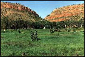
Based on African and American herding practises, Chris has trained semi-wild Kimberley Shorthorn cattle as a herd, and he uses controlled grazing in varying lengths and intensity, depending on desired outcome, to encourage growth of preferred species, to maintain vegetative cover, to redevelop a soil profile, implement strategic firebreaks and stabilise riparian zones. Cattle are moved between paddocks on an hourly to daily basis, to prevent them overgrazing and denuding any area. Amazingly, late in the dry season, land that is under this grazing regime has a dense cover of annual and perennial vegetation and areas previously denuded now support soil, vegetation and stock (Plates 2 & 3). The basic concept of this work is the improvement of soil health, through the introduction of micro-organisms, burrowing insects like dung beetles, and working and composting the soil by the action of cattle hooves. Chris argues that current pastoral management practices are not sustainable, because the asset that maintains the vegetation and therefore supports the cattle, the soil, is being burnt-off or washed into the rivers.
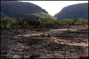
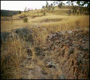
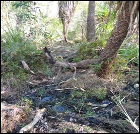
Areas of the station that are not currently under this intensive holistic management technique exhibit the classic signs of fire and uncontrolled grazing. Frequent, hot, late dry season fires have removed the vegetation and burnt away the soil, leaving bare sand and rock. Feral cattle, yet to be brought into a herd, over-graze areas, reducing them to dust-bowls. When the seasonal rains come, there is no protection for the soil, and it erodes into the watercourses and eventually out to sea. Erosion starts in even the smallest headwater subcatchments, where active headcuts can be seen working their way upstream, eroding soil profiles and peat deposits that took 100s to 1000s of years to accumulate (Plates 4 & 5).
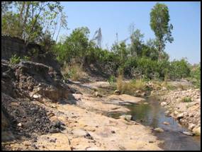
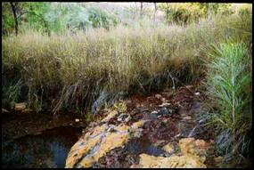
Further downstream, the combined effects of fire, grazing and loss of vegetation become more visible, whereby recent rainfall events have resulted in catastrophic erosion of the creeklines (Plates 6 & 7). Chris Henggeler estimates he is loosing one million tonnes of peat and topsoil per year through this broadsheet and gully erosion. The active erosion of established soil profiles is evidence that this is a relatively new phenomenon, and that prior rainfall events of similar magnitude did not result in such erosion.
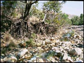
Kachana Station supports a diminishing number of pockets of remnant rainforest as well as raised Melaleuca peat springs and seeps (Plates 8 & 9). Once the protective cover of this vegetation is lost, the peat dries-out and peat layers, which carbon dating shows took up to 3000 years to establish (Karl-Heinz Wyrwoll, University of Western Australia) are being lost in a couple of years through erosion and fire. It is generally accepted that vegetation provides resistance to flows and therefore the loss of vegetation to fire and overgrazing will make river systems sensitive to flooding. Floods, which previously the landscape could accommodate, may now cause catastrophic erosion due to clearing (Lovett & Price, 1999), as was seen at Kachana in Goanna Creek following 1:10 year rainfall events in 2000 and 2001 (Plates 6 & 7). What happens in the headwaters has repercussions for lowland reaches, whereby catchment clearing and associated increased flows may result in extensive flooding further downstream, as is so often reported in the daily news, when yet another town is inundated by floodwaters.
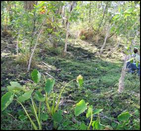
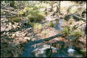
On the parts of Kachana Station being intensively managed, erosion is being minimised. Over the last 10 – 15 years Chris has managed to revegetate eroded, seasonal creeklines, which are now permanently flowing as the vegetation acts like a sponge and intercepts and holds back the wet season rains. Even when the big rainfall events occur the creeks run clear, whilst adjacent un-managed catchments are turbid and actively eroding. As Chris notes, his station has a similar annual rainfall to Perth, and it falls over a similar length of time. His challenge is to hold-back the rainfall, so it doesn’t runoff too fast. By revegetating the headwaters of the subcatchments and the creeklines, Chris is holding water on the landscape longer. The vegetation intercepts the rain and reduces run-off, it also reduces evaporation from the soil profile in the dry season, and holds the soil together to prevent erosion. The proof is perennial creeklines that are vegetated, and still retain an intake peat layer that soaks-up the rain and gradually releases it throughout the dry season (Plates 10 & 11).
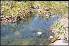
The benefits of this holistic management to the waterways are obvious. Many aquatic fauna of the Kimberley require permanent pools as refuges and dislike high silt loads. Minimising erosion will reduce sediment loads and help preserve these critically important refuge pools. Healthy riparian vegetation also provides shade and keeps the water temperature lower, and helps prevent the proliferation of problem algae (Plates 12 & 13). Vegetation slows runoff into the creeks, intercepts nutrients and sediment, and also provides an energy source to in-stream fauna, directly in the form of leaf litter and indirectly through the input of insects, fruits and seeds, all of which fish feed upon. It also provides habitat in the form of large woody debris falling into the channel. Therefore, the management practices employed by Chris appear to be truly holistic, not only benefiting the landscape, but also benefiting the watercourses.
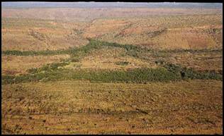
As you take off from the bush airstrip at Kachana and gain height, the valley rapidly grows small with distance (Plate 14) and quickly seems insignificant in this massive landscape. Is what Chris is achieving on too small a scale to be widely applicable? Or is this a way forward, a means for sustainable management of the Kimberley rangelands. Even if not immediately applicable on a wide scale, maybe there is value in raising awareness and showing stakeholders (i.e. Industry Rep groups like PGA, Dept CALM, DAWA, DoE, DOLI, KDC, FESA, SWEK, Aboriginal Communities, DIA) the problems and possible solutions.
Where to NextMany of the benefits of the holistic management practices implemented by Chris Henggeler are inferred from personal observation, and are supported by a comprehensive photographic record. However, for this approach to gain acceptance as a potential management tool for Kimberley rangelands (and waterways), and possibly for wider application across Australia, where “European” agricultural practices do not appear to be sustainable, there is a need to gain scientific credibility.
With respect to watercourse management, studies are needed to pull apart the effects of grazing and fire from climatic variability on catchment hydrology and catchment runoff coefficients. A better understanding is needed of the erosion characteristics and sediment dynamics of these catchments and how they are affected by fire, over-grazing, and the management implemented by Chris.
Current concepts of how the ecology of Kimberley river systems function is primarily based on work from temperate regions and the wet-dry tropics of Australia. Studies are required to determine the role of riparian zones to ecosystem processes in these water courses, to define the energy sources drive the food webs of these systems, and how issues such as siltation and sedimentation, fire, seasonal versus permanent flows affect the fauna of head water and higher order streams and rivers. We need to define and understand the ecology of these waterways and how the ecology it is affected by fire, grazing and by the holistic management implemented at Kachana.
AcknowledgmentsFirstly, I would like to thank Chris and Jacqueline Henggeler for their hospitality, informative discussions and insights to land management practises at Kachana. I would also like to thank Lee Scott-Virtue and Dean Goodgame of Kimberley Specialists for facilitating and providing logistical support for my visit to Kachana. Thanks also to Lee Scott-Virtue (Kimberley Specialists), Shireen Jung (DAWA), Jane Rapkin and Mark Pearcey (DoE) and Chris Henggeler (Kachana Station) for constructive feedback on drafts of this discussion paper.
ReferencesKohen, J.L. (2003) Proceedings of the 2 nd biannual Kimberley fire forum, Brumby Base, El Questro Wilderness Park, East Kimberley, Western Australia, 3-6 May 2001, published by Kimberley Specialist, Kununurra, Western Australia. Lovett S. & Price P. (1999). Riparian Land Management Technical Guidelines, Volume One. Principals of Sound Management. Land & Water Resources Research & Develoment Council. Canberra. Water & Rivers Commission (1997). The State of the Northern Rivers. Publication No. WRAP 10, published by the Water & Rivers Commission, Perth, Western Australia |
|||||||||||||||||||||||||||||||||||